From 1955–1988, low-level waste solutions from the processing of uranium and irradiated nuclear fuel were discharged into unlined earthen storage basins at the Savannah River Site (SRS) F-Area [1]. Over the decades, radioactive contaminants including uranium and iodine-129 (I-129) have leaked out of the basins and into the groundwater of the surrounding wetlands, and are now present at levels that exceed regulatory thresholds.

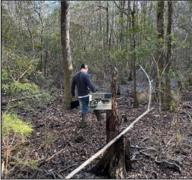
In March 2023, scientists from NSD’s Applied Nuclear Physics (ANP) program returned to the SRS F-Area wetlands to conduct handheld gamma-ray surveys in order to map the intensity and spatial distribution of radioactive contaminants in the area. Using ANP’s Scene Data Fusion (SDF) radiological mapping technology (see, e.g., [2]), roughly 0.25 km2 of dense forested wetlands were surveyed. Several uranium hotspots (up to roughly five times higher than the SRS natural background) were identified, and more detailed analysis is ongoing both to refine the mapping results and to examine possible yearly variations compared to measurements from the team’s 2022 campaign. In Fig. 1, a Savannah River National Laboratory (SRNL) scientist can be seen carrying LBNL’s MiniPRISM radiation imager through the SRS-F Area wetlands. Fig. 2 shows SDF results, including a preliminary reconstruction of low energy gamma-ray intensities during one survey. In addition to the SDF mapping systems that are sensitive to uranium radioactivity, LBNL is exploring whether silicon drift detectors are a viable technology to map the I-129 in situ. These efforts are part of the larger DOE-EM ALTEMIS project, which aims to develop long-term remediation and monitoring strategies for contaminated DOE legacy sites and have used the F-Area wetlands as a test bed.